A research and travel grant from the Central European History Society allowed me to spend five weeks conducting dissertation research at the Landesarchiv Schleswig-Holstein in Schleswig, Germany. My dissertation project, “Shoring Up the Nation: Making the North German Landscape,” brings together histories of spatial planning and the environment by examining land use and infrastructure projects on the Wadden Sea coast of Schleswig-Holstein. This region was a source of political and cultural anxieties beginning with its incorporation into the Prussian state in the 1860s. It was also the target of concerted settlement and development projects, from utopian land reclamation plans of the Nazi era to West German subsidies for areas considered economically disadvantaged. My work underscores this region’s importance as both a politicized space and a unique ecosystem, today home to Germany’s largest national park and a UNESCO World Heritage Site.
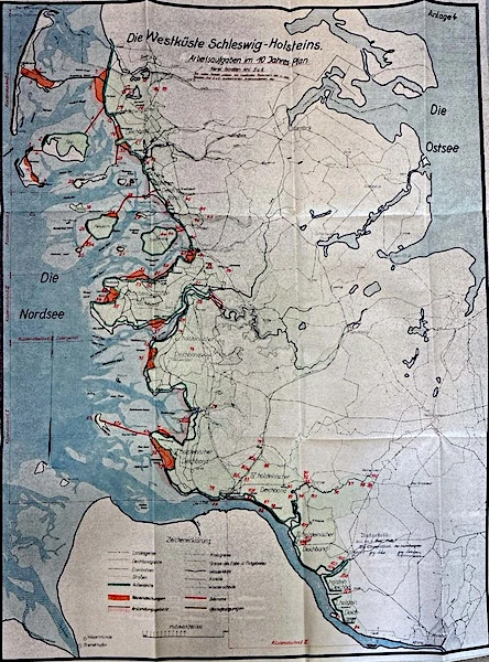
While at the Landesarchiv, I focused my attention on the records of state bodies associated with land reclamation, dike construction, and physical planning. These include state entities at the Land level, including the Ministry of Agriculture and the State Chancellery, as well as local bodies responsible for coastal engineering and construction in Husum, Heide, and Itzehoe. These collections also allow me to note continuities and ruptures in planning practice across political regimes, from the nineteenth-century efforts of the Prussian state to large-scale planning of the 1930s and post-World War II regional development. During my trip, I found maps, reports, and correspondence regarding the Ten-Year Plan of Gauleiter Hinrich Lohse, a program of land reclamation and dike building with the ultimate goal of totally transforming the Wadden Sea mudflats into arable land. These materials also indicated the importance of local dike associations, traditionally responsible for the upkeep of dikes and the maintenance of the coastline.
My time at the Landesarchiv reinforced the importance of regional and national identities in understanding the physical reshaping of the Wadden Sea coast. The German–Danish borderland was politically volatile throughout the late nineteenth and early twentieth centuries, especially in the years surrounding the 1920 border plebiscite and political mobilization within the Danish-speaking minority population in the late 1940s. While reading files related to postwar subsidies aimed at supporting the borderland economy, I found references to the importance of “strengthening Deutschtum” alongside proposals for agricultural settlements and coastal protection installations. In addition to these longstanding ethnic tensions, this region was also heavily impacted by the post–1945 refugee crisis. I found that this too played a role in the thinking of planners and policymakers, who saw land reclamation and settlement as a means of integrating refugees in the region.
During this trip, I was able to begin research in one of my primary archives and develop a roadmap for completing my dissertation. Thank you, CEHS!